K
Kathleen Martin
Guest
Given today’s technological advancements, photogrammetry seems new, but actually, it’s really old. The method of reconstructing measurements is rooted in principles of perspective and projective geometry practiced by artists like Leonardo da Vinci and formalized into a science by German mathematicians in the late 19th century. Yet the photogrammetry field is rapidly evolving through innovations in software and aerial photography.
What Is Photogrammetry?
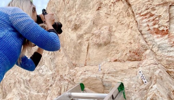
Photogrammetry involves taking photos of an object or environment from different angles and using these images to generate reliable measurements. Professionals often depend on high-quality cameras to take photos, attaching them to an aerial craft, like a drone, or to a ground-based support system, like a tripod, or simply using a handheld camera.
WHAT IS PHOTOGRAMMETRY?
Photogrammetry is the science of reconstructing objects and environments in the physical world through photographs. The technique involves stitching together large collections of overlapping photographs to create topographical maps, meshes, and lifelike 2D and 3D digital models.
After taking photos from different locations, teams can gather enough visual data to inform drawings, topographical maps, meshes and lifelike 3D models. Advanced software tools have made the last option more prominent since professionals can leverage these technologies to create digital assets with pixel data gathered from photographs. The technique has become essential for various tasks, including surveying construction sites and flood zones, assessing crop health and exploring fossil sites.
In January of 2021, at a clay mine near Golden, Colorado, Alena Iskanderova made a startling discovery: The tracks of an ancient relative of the crocodile — once preserved for some 100 million years — had been largely erased by erosion.
In the 11 years since paleontologist Martin Lockley, an associate curator at the University of Colorado Museum of Natural History and professor emeritus at the university, first documented the tracksite, the fossilized footprints left by the animal had lost much of their depth — from roughly 7 to 12 millimeters down to 3 to 4 millimeters, Iskanderova said.
That the effects of the elements could visibly diminish the tracks in such a short time points not only to their fragility in the face of climate change and other anthropogenic threats, Iskanderova said, but the importance of photogrammetry as a means of preserving the geologic record.
“Sometimes tracks are the only presence of animals in any paleoenvironment. So [photogrammetry] is very important for us to know what kind of animals were there,” she said. “The tracks also show us their behavior. Sometimes we can tell, for example, that there was a group of dinosaurs migrating from one point to another.”
Continue reading: https://builtin.com/software-engineering-perspectives/photogrammetry
What Is Photogrammetry?
Photogrammetry involves taking photos of an object or environment from different angles and using these images to generate reliable measurements. Professionals often depend on high-quality cameras to take photos, attaching them to an aerial craft, like a drone, or to a ground-based support system, like a tripod, or simply using a handheld camera.
WHAT IS PHOTOGRAMMETRY?
Photogrammetry is the science of reconstructing objects and environments in the physical world through photographs. The technique involves stitching together large collections of overlapping photographs to create topographical maps, meshes, and lifelike 2D and 3D digital models.
After taking photos from different locations, teams can gather enough visual data to inform drawings, topographical maps, meshes and lifelike 3D models. Advanced software tools have made the last option more prominent since professionals can leverage these technologies to create digital assets with pixel data gathered from photographs. The technique has become essential for various tasks, including surveying construction sites and flood zones, assessing crop health and exploring fossil sites.
In January of 2021, at a clay mine near Golden, Colorado, Alena Iskanderova made a startling discovery: The tracks of an ancient relative of the crocodile — once preserved for some 100 million years — had been largely erased by erosion.
In the 11 years since paleontologist Martin Lockley, an associate curator at the University of Colorado Museum of Natural History and professor emeritus at the university, first documented the tracksite, the fossilized footprints left by the animal had lost much of their depth — from roughly 7 to 12 millimeters down to 3 to 4 millimeters, Iskanderova said.
That the effects of the elements could visibly diminish the tracks in such a short time points not only to their fragility in the face of climate change and other anthropogenic threats, Iskanderova said, but the importance of photogrammetry as a means of preserving the geologic record.
“Sometimes tracks are the only presence of animals in any paleoenvironment. So [photogrammetry] is very important for us to know what kind of animals were there,” she said. “The tracks also show us their behavior. Sometimes we can tell, for example, that there was a group of dinosaurs migrating from one point to another.”
Continue reading: https://builtin.com/software-engineering-perspectives/photogrammetry