K
Kathleen Martin
Guest
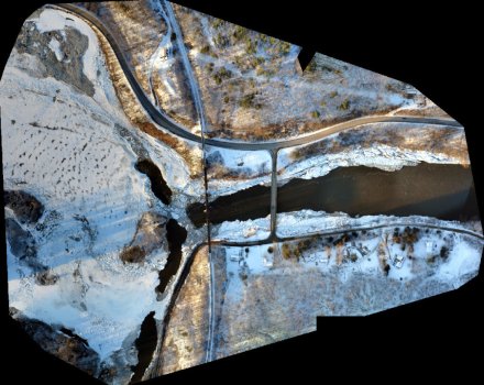
Most mapping and surveying professionals see clear value in using drone technology for their work. Low-cost, fast-moving drones equipped with high-quality cameras and sensors can cover large areas of territory and deliver detailed and accurate information. This information that can be accessed, analyzed, and put to use immediately, saving surveying and mapping operations time and money.
Leaders in this sector were early adopters of UAV technology, and, over the years, they have found many ways to integrate drones into their projects. “Many industry experts realized that drones could quickly and inexpensively cover large areas, as well travel to hard-to-reach places,” Christian Stallings, a certified photogrammetrist and Director of Operations at Alynix, told Commercial UAV News. “Also, they understood that these vehicles could be equipped with remote sensing technology and sensors capable of delivering high-quality data.”
These realizations have spurred heavy investment in drones and related technologies. According to the 2022 study “Aerial Imaging - Global Market Trajectory & Analytics,” the worldwide aerial imaging market could hit $4.6 billion by 2026. The report asserted that the growth is driven by improvements in imaging technology, as well as “processing methods, collection platforms and cloud storage and analytics platforms.”
Looking ahead, the report stated that the aerial imaging market will continue to expand as businesses and government entities become more aware of its value in areas such as urban planning, energy exploration, security, and environmental management.
So, where do these efficiencies come from and how can the value of drones in surveying and mapping be defined? First, drones can go places where human beings cannot go, greatly expanding the scope and usefulness of surveying and mapping projects. And, as stated earlier, UAVs equipped with the right cameras and sensors enable mapping and surveying professionals to capture hundreds of aerial images and thousands of pieces of information quickly and efficiently.
Speaking of sensors and cameras, drones have changed the "photogrammetry vs. LiDAR" debate, an ongoing concern in the world of surveying and mapping. In simple terms, photogrammetry uses photographs to make measurements, while LiDAR, short for “Light Detection And Ranging,” gets its measurements using light or lasers. Both are powerful data capture technologies that become even more powerful when paired with drones.
Continue reading: https://www.commercialuavnews.com/surveying/defining-value-with-drones-as-a-tool-for-surveying-and-mapping-applications-2022